Open convection cells over the Negev?
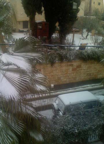
Jerusalem was under siege, again. Last time it was Bush. This time, it was snow because of which we had two snow days. So, I didn't have to teach and instead could build a snowman with my kids.
Now for those who are unaware of Jerusalem's climate, this is not unique. In fact, the average annual amount of snow in our capital is 10 cm, just as much as we received this year. Of course, it varies quite a lot. A fifth of the years that have no snow, while the record is of 1 meter in Jerusalem's storm of the century, which took place in 1920. Incidentally, in 1470, snow fell continuously for 2 weeks, and Jerusalem was besieged for a whole month.


Anyway, the actual storm included very strong winds (over 100 km/hr gusts), and snow at different places, including Jerusalem, the Galilee mountains in the North, and even as far south as the Mitzpe Ramon (over looking the Ramon Crater, i.e., snow in the desert!).
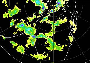
During the storm, I stumbled upon the following radar animation. When looking at it, I realized a few interesting things about it.
First, it is quite evident that very little rain passes into Jordan. The reason has to do of course with orographic effects. As the clouds move over Israel, they have to climb up 800 meters due to the topography of the Judea and Samaria hill chain. As the air mass has to rise, it cools adiabatically and further condenses water vapor, forcing it to rain out. After passing the hills, the air has to descend 1200 meters into the Jordan valley. It thus heats up and hinders any condensation. It if for this reason that my western suburb gets almost twice the annual amount of rain as the Eastern neighborhoods of the city, just 20 kms away. Then, as the clouds have to climb up the Jordanian mountains (typically 1500 meters above the Jordan valley), a little more rain can be squeezed from the clouds.
The second thing to note about the radar is that there appears to be a large building at an azimuth of about 65° to 70° from the rain radar (i.e., around ENE from the radar). The building has a large westward facing wall. This can be seen in the form of a reflection along a streak, which reflects the rain coming from the WNW direction, that is, as the rain clouds move to the SE, the rain along the streak moves in the opposite direction!
The third interesting point to note about the rain is that over the southern part of the country the rain appears to be part of open cell convection, that is, convection in which the rising air (and therefore rain) takes place along the boundary of convection cells, while the descending air does so in the center of the cells.


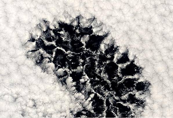
For comparison, these are marine clouds over the Pacific. The center includes an area with open cell convection (air rises and forms clouds on the cell boundaries), surrounded by closed cell convection (which is what most people are used to).
To me this seems strange, since I was always under the impression that open cell convection appears only under certain conditions and only above oceans. Of course, it could be that this is not an example of open cell convection.., but if it is, then what caused it to appear over land? And if not, what is it then? A coincidence?

Comments (8)
Hi Nir,
Nice catch.
It seems like the time it takes the structures to change is longer than it takes them to travel across Israel. Isn't it possible that the cells came to be over the Mediterranean sea, and that only then they were swept onto land?
I wonder if these structures also appear when the wind flows to the west...
Given that Israel doesn't get rain from easterly winds (just sand), it would be hard to see the hexagonal pattern in the rain radar. In any case, it is the first time I see it over israel, whether by radar or satellite.
As for your first comment... yes, it appears to have formed over the mediterranean. The problem is that I couldn't find any consistent explanation to what determines whether open celled convection arises.
The several explanations I did stumble upon include the location of the warming/cooling (e.g., warming from the bottom as opposed to cooling from the top), or the height dependence of the eddy viscosity of the atmosphere. Usually, the literature talks about mesoscale convection over the oceans, but I am not sure it pertains here.
Anyway, it might be related to the fact that it was a relatively a very cold air mass going over a relatively very warm sea (I wouldn't call the Mediterranean an ocean), but I am not sure.
Surely the streak is not a real reflection but a computer glitch, since you will notice it is perfectly radial relative to the radar position. Or were you joking to see if we were paying attention? :-)
MK
Note that the streak covers two radial resolution lines, and in one it is stronger. Thus it appears more like an analog effect and not a computer glitch. Thus, a large building seems like the most reasonable explanation. (The topography in the radar's vicinity is otherwise flat).
I wonder if the residents of that building realize that they are being microwaved every 10 seconds or so...
Great article. Well written and very useful. Thanks alot!
I think the residents of the alleged big (or actually tall and narrow) know that they are being microwaved every so-and-so seconds.
As I looked at the radar picture, I compared it to a regular map of Israel minimized to the same scale. That led me to find that the "epicenter" of the radar eye is near the city of Lod. Which leads to the thought that the radar is in fact located at the adjacent Ben-Gurion intl' airport. I further researched to find that the radar output shown above, is in fact from a radar operated by a company called Sha'ham Mekorot (a company dealing with cloud seeding). And matter of fact is, that the Ben-Gurion intl' is housing their radar (along with their planes as well).
I tried finding the exact locations of the Sha'ham radar using google-maps but the resolution isn't high enough even to locate the control tower.
Nonetheless, knowing that clouds radar, and air-planes radar operate on two different spectrum scales, we know that these two radars are separate. So finally, I come to the conclusion that probably the residents of the microwaved building are in fact the residents of the control tower of Ben-Gurion intl'. And being flight operators and so, I would assume they know about the clouds radar operating near them, and have also read "Radars 101".
Hope they have a good health-care :)
Shaviv, Sorry for posting out of subject.
I just came across this graph: http://www.fao.org/DOCREP/005/Y2787E/y2787e03b.htm#FiguraB
It shows detrended temperature and the length of day on earth. Clearly there is a correlation, and it might be casual as warmer oceans should slow earth down (due to thermal expansion) and vice versa.
However, what intrigued me is that changes in length of day come before changes of delta T: I would expect the opposit. I wondered wether this could support the theory of a large influence from cosmic rays. As their effect, according to Svensmark, is mostly over the large oceans, could it be that the ocean warms before land because most of the forcing is due to changes in clouds over oceans? A bit speculative, I realize this, but I have no other idea as to why the length of day changes after temperature.
Hello Nir,
Here is a nice satellite image showing the development of open convection cells over the Sea of Okhotsk taken on 28th January 2011.
http://news.gismeteo.ru/pictures/63432320804.jpg
The wind direction is from the north bringing cold dry continental air from the Province of Magadan out over the Sea of Okhotsk. Along the coast the sea is frozen, but as soon as the air mass crosses over the open water, the temperature difference between the seawater and the cold dry air permits evaporation and the development of an unstable surface boundary layer.
As the cold air aloft is drier and under adiabatic movement will be denser at the sea surface than the moist surface boundary layer, vertical mixing is possible. This overturn takes place driven by the density contrast and causes up-side down convection. The image shows the development southward in the air mass of the rising lattice cloud structures surrounding the clear open cells of descending dry air.